The Benthic Indicator Species Index (BISI) is a methodology developed to evaluate benthic habitat quality status or quality developments based on benthic community data. This page gives an overview of the methodology and applications and provides the available (background) information in the form of reportings, protocols and assessment tools. Developed BISI assessment tools and results of applications are made available here.
BISI in short
With the BISI indicator, the occurrence (either densities, biomass or presence/absence data) of combinations of specific indicator species are compared with predefined reference levels (BISI internal reference) for those species representing a good quality status. Basically, area-specific indices (indicator species with reference levels) are constructed with the BISI methodology. The most recent version is BISI v3, which comes with a protocol for application (see below). Additionally ‘Assessment tools’ for application including a manual in the assessment tools themselves are available. With BISI v3 the selection of indicator species and derivation of reference levels is part of the methodology and takes place at the level of (high aggregation) ecotopes (e.g. MSFD broad habitat types (EUSeaMap, 2021) or other ecotope classifications with clearly distinguishable benthic communities). Herewith, the BISI is equipped for generic application. BISIs at the level of ecotopes can be applied in other areas (within the same geographical region). BISIs for compiled (ecotope) areas can easily be constructed taking surface distribution into account. In case of sufficient and representative benthos monitoring data BISI-values (representative for the quality status) can be calculated and compared between assessment moments and/or between different areas.
With the current methodology (BISI v3) indicator species are selected in a standardized way. Indicator species are selected at the level of ecotopes on basis of either being characteristic, being indicative for at least one of the (area specific) dominant disturbances, or being characterized by a combination of biological traits. Additionally, indicator species are preferably ‘smart species’ in such a way that potential differences in occurrences can be observed with realistic monitoring efforts and techniques (resulting in sufficient power of statistical tests). Selected indicator species should be present in the vicinity or have opportunities to return to the area of concern. Reference values are preferably obtained from suitable reference areas. When reliable reference data lack, (BISI) internal reference values are derived from current and maximum observed occurrences considering natural variation. Therefore a standardized decision scheme, taking recent historic data availability and current monitoring efforts, possible availability of reference (as indicated) or alternative areas, and suitability of monitoring techniques or possible alternative techniques, is used as guidance to retrieve area specific reference occurrences for BISI indicator species.
The BISI provides an assessment of the general quality status of an ecotope (habitat) or compiled (aggregation of ecotopes) area and several specific assessments. Specific assessments should identify possible causes and effects of the observed quality status (and their importance), based on subsets of indicator species. Specifically developed for the benthic quality status in marine waters based on benthos; application in other systems and types of habitats and inclusion of other types of biota as indicators is however possible. At present applications and examples are available at (sub)regional scale, national scale, scale of Natura 2000 areas and Marine Protected Areas (MPAs) and for specific management areas (parts of MPAs with different protection status). BISI can be used to evaluate current quality status, trends in quality status and/or to determine the effect of management measures with specific monitoring designs (e.g. Before-After-Control-Impact designs). Threshold levels (management targets for desired sufficient good quality status) with regards to Marine Strategy Framework Directive (MSFD) or Habitat Directive (HD) application are suggested.
BISI formula
The BISI is calculated as the sum of observation to reference ratios for individual indicator species; optionally the relative importance of indicator species is distinguished in the specific assessments using indicator values (‘weights’); individual indicator species results are combined by calculating the geometric mean (logarithmic transformation).
BISI = exp((1/S)*∑(IVi*ln(Oi/Ri)))
BISI = Benthic Indicator Species Index; S = Number of indicator species included; IVi = Species specific Indicator Value calculated as species specific standard indicator value ivi (value between 0-1) divided by average indicator value ivavg; Oi = Observed occurrence species i (either presence/absence ratio, density or biomass); Ri = Reference occurrence species i (presence/absence ratio, density or biomass under reference conditions). (‘exp’ is similar to putting e to the power of the formula as indicated, which equals the inverse natural logarithm, as a back-transformation of the natural logarithm (ln) taken from the occurrence-to-reference ratios).
Protocols and applications
The BISI v3 protocol for generic application describing the BISI methodology is available from here:
- Wijnhoven (2023a). Protocol Benthic Indicator Species Index (BISI): Protocol BISI for generic application (BISI v3). Version v170424. Ecoauthor Report Series 2023 – 01, Heinkenszand, the Netherlands.
At present specific indicators (BISIs) are developed according to v3 for evaluation of marine (and estuarine) HD habitat types (i.e. H1110, H1130, H1140, H1160) and HD areas in the Netherlands (including the distinguished dominant ecotopes describing those habitat types), situated in the Dutch delta region (e.g. Oosterschelde, Westerschelde), the Dutch Wadden Sea (including Eems-Dollard) and the intertidal Dutch North Sea, potentially applicable in other areas of the same habitat type and outside the Netherlands as well. Also BISIs according to v3 (however consolidating earlier identified indicator species with reference levels) are available for distinguished areas (i.e. MPAs including Natura 2000 areas and MSFD areas) and ecotopes describing the sublittoral Dutch North Sea. Both BISIs currently make use of the two most important monitoring techniques in use in the Netherlands; (box)corer – and benthic dredge related monitoring (that can however be another sampling technique dependent of the substrate type and accessibility, applied in a standardized way) with indicator species related to the most appropriate technique. (For the specific habitat, largely consisting of coarse sediment, gravel and boulders, indicated as ‘H1170 – reefs of the open sea’, present on the Klaverbank, the methodology is based on monitoring with Hamon grabs and video footage). According to v3 also BISIs are developed distinguishing the 6 same ecotopes (or broad habitat types; offshore circalittoral mud, – sand and – coarse sediment, and circalittoral (including infralittoral) mud, – sand and – coarse sediment) solely making use of grab and (box)corer data (indicative approximately 0.1 m2) for generic application and testing in the international context with regards to OSPAR region II (Greater North Sea) and the southern subregion in particular.
Assessment tools according to v3:
- Wijnhoven (2023b). Assessment tool ‘Benthic Indicator Species Index (BISI)’: Application of BISI v3 in the Dutch North Sea with consolidation of earlier identified references. v021023.
- Wijnhoven (2023c). Assessment tool ‘Benthic Indicator Species Index (BISI)’: Application of BISI v3 in soft sediment habitats of OSPAR region II (Greater North Sea region). v031023.
- Wijnhoven (2023d). Application of BISI v3 for marine Habitat Directive habitat types of the Dutch ‘Delta-waters’, the Wadden Sea and the coastal zone of the North Sea. v061023.
All assessment tools include guidance for application.
Compared to BISI v2 the formula to calculate a BISI-score has been adjusted by placing the Indicator Value (IVi; an indicator species specific weight factor) outside the log-term. Additionally the IVi-values have been reduced to half of the original value in case the IVi was less than 1. Both adjustments lead to more emphasis on the most indicative species in the assessment results and are particularly meant to achieve more distinction between the specific assessments to improve detectability of possible pressures leading to the observed quality status or – development as indicated by the BISI and/or indicating possible consequences of observed quality status or – developments with regards to ecological functioning. As the formula has been changed this had consequences for the calculation of the pooled standard deviation as well; which has been adjusted accordingly.
At the moment BISI v3 has been applied for assessment of the benthic habitat quality status (D6C5) with regards to the Dutch Marine Strategy part 1 (EU MSFD Article 8 reporting 2024). Factsheets are currently in public consultation and being finalized. The assessment results as being reported in the Dutch Marine Strategy and described in detail in a background report will soon be shared here:
- Wijnhoven, S. (2023e). Beoordeling kwaliteitstoestand Nederlandse deel Noordzee op basis van de Benthische Indicator Soorten Index (BISI). Toestand en ontwikkelingen van benthische habitats en HR-/KRM-gebieden gedurende 2016-2021 in vergelijking tot voorgaande jaren. Ecoauthor Report Series 2023 – 02, Heinkenszand, the Netherlands.
Sensitivity and differences between versions
At the moment results from earlier version are provided here (which will soon be replaced by example from v3 as well).
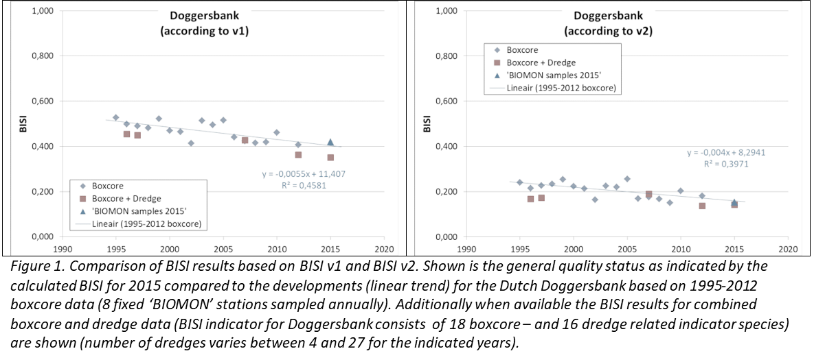
Differences between BISI versions are best illustrated with an example. Figure 1 shows the results of general quality status evaluation for the Dutch Doggerbank based on the versions v1 and v2. As indicated, there might be (and is) a difference in the absolute BISI values that cannot be directly compared between v1 and v2. However the results show a similar decreasing trend in quality status (BISI score) in both cases with minimal relative differences for individual measurements (year x technique combination). This despite that results are based on a relative low sampling effort (e.g. only 8 boxcore samples) and trends calculated on about half of the selected indicator species for the Doggerbank (trend based on 18 boxcore related species of in total 34 indicator species including the dredge related ones). It is suggested to use a monitoring programme consisting of 20 boxcore – and 15 dredge stations (in case of the Dutch Doggersbank considering current ‘natural’ variation) to achieve sufficient power for evaluation of the quality status (including detection of possible causes and effects of observed quality via specific evaluations; e.g. Wijnhoven & Bos, 2017).
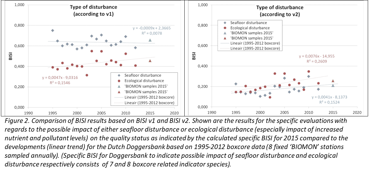
However, with regards to specific evaluations, results might slightly deviate, as in those cases only a subset of the indicator species is used (here respectively only 7 and 8 indicator species to evaluate the possible role of seafloor disturbance and ecological disturbance on the observed quality status; Figure 2). Differences in relative BISI levels are largely the result of working with natural logarithms instead of 10log in case of v2. Deviating trends are largely the result of differences in relative importance of species (using indicator values either or not transformed with v2 compared to v1) in the calculations. In the case of the Dutch Doggerbank, the stable level of seafloor disturbance (according to v1) might be a slight reduction of the impact of this from this pressure (as indicated by v2). Both versions seem to indicate that the relative impact of increased nutrient and pollutant levels (ecological disturbance) is decreasing. The relative importance of the one disturbance compared to the other might however be less clear than indicated by v1. Such aspects should be clarified by testing with sufficient power (e.g. in this case when additional data according to the Dutch MSFD monitoring programme come available; Wijnhoven (2019e), and by ground truthing with pressure data (e.g. application in various circumstances).
Current developments and future applications
At the moment the BISI (v3) is used in the Netherlands for MSFD assessments and evaluation of sea floor integrity (D6) in particular, used as one of three indicators for D6C5 (assessing the overall habitat condition), and informing D6C3 (assessing the spatial extent of adverse effects of physical disturbance).
In the Netherlands the BISI (v2) has already been used for the quality status analyses of Habitats Directive habitat types (Article 17 reporting); H1110 (Permanently submersed sandbanks) and H1170 (Reefs) in particular. At the moment a specific BISI to assess ‘Structure and Function’ under the Habitats Directive (BISIs&f according to v3) is in development for all marine HD habitat types (H1110, H1130, H1140, H1160, H1170), to be applied in 2024, to inform the HD Article 17 reporting in 2025.
First tests of application of the BISI on basis of international monitoring data have taken place within OSPAR. A proposal for implementation of the BISI in the framework of Benthic Habitat (BH) quality indicators as part of the OSPAR common indicators instrumentarium is in preparation and under discussion within the OSPAR – Benthic Habitats Expert Group (OBHEG). Application of the BISI is foreseen for specific international test cases and the Greater North Sea (OSPAR region II) in particularly.
The focus of current international quality status assessments (e.g. MSFD – and OSPAR assessments) with regards to sea floor integrity is predominantly on large-scale assessment of expected impact from dominant pressures taking sensitivity of habitats into account. It is however of importance to verify the quality status with benthic observations, which can be related to specific impacts and habitat changes. Herewith key processes and management options can be identified or evaluated. The BISI could potentially fill in this gap.
Of special interest is at the moment the application of BISIs at different spatial scales investigating effects of spatial variability and data density on BISI results and the impact of possible (sub)regional variation on the indicator, with regards to generic application. Also more small scale applications with more detailed information on habitat – and community variability and (known) pressure variability is foreseen. Test cases and their results will be presented here when available.
Overview of BISI related protocols, assessment tools and reports
Latest versions according to v3:
- Wijnhoven (2023a). Protocol Benthic Indicator Species Index (BISI): Protocol BISI for generic application (BISI v3). Version v170424. Ecoauthor Report Series 2023 – 01, Heinkenszand, the Netherlands.
- Wijnhoven (2023b). Assessment tool ‘Benthic Indicator Species Index (BISI)’: Application of BISI v3 in the Dutch North Sea with consolidation of earlier identified references. v021023.
- Wijnhoven (2023c). Assessment tool ‘Benthic Indicator Species Index (BISI)’: Application of BISI v3 in soft sediment habitats of OSPAR region II (Greater North Sea region). v031023.
- Wijnhoven (2023d). Application of BISI v3 for marine Habitat Directive habitat types of the Dutch ‘Delta-waters’, the Wadden Sea and the coastal zone of the North Sea. v061023.
Earlier versions and applications (v2 and v1):
- Wijnhoven, S. (2019a). Protocol Benthic Indicator Species Index (BISI): Protocol BISI for generic application (BISI v2), Version v311219 as an update of v181218. Ecoauthor Report Series 2019 – 05, Heinkenszand, the Netherlands.
- Wijnhoven, S. (2019b). Assessment tool ‘Benthic Indicator Species Index (BISI)’: Application of BISI v2 for marine Habitat Directive habitat types of the Dutch ‘Delta-waters’, the Wadden Sea and the coastal zone of the North Sea. v070120.
- Wijnhoven, S. (2019c). Assessment tool: ‘Benthic Indicator Species Index (BISI)’: Application of BISI v2 in the Dutch North Sea with consolidation of earlier identified references. v311219.
- Wijnhoven, S. (2019d). Assessment tool: ‘Benthic Indicator Species Index (BISI)’: Application of BISI v2 in soft sediment habitats of OSPAR region II (Greater North Sea region). v311219.
- Wijnhoven, S. & Van Avesaath, P.H. (2019). Benthische Indicator Soorten Index (BISI) voor mariene habitattypen in Natura 2000-gebieden. Uitwerking beoordelingsmethodiek inclusief monitoringvoorstel voor mariene habitattypen van de Habitatrichtlijn gelegen in de Deltawateren, het Waddenzeegebied en de kustzone van de Noordzee. Ecoauthor Report Series 2019 – 03, Heinkenszand, the Netherlands (in Dutch).
- Wijnhoven, S. (2018a). T0 beoordeling kwaliteitstoestand NCP op basis van de Benthische Indicator Soorten Index (BISI). Toestand en ontwikkelingen van benthische habitats en KRM gebieden op de Noordzee in en voorafgaand aan 2015. Rapport Ecoauthor & Wageningen Marine Research. Ecoauthor Report Series 2018 – 01, Heinkenszand, the Netherlands (in Dutch).
- Wijnhoven, S. (2018b). Protocol Benthic Indicator Species Index (BISI): Protocol BISI for generic application (BISI v2), v181218. Ecoauthor Report Series 2018 – 04, Heinkenszand, the Netherlands.
- Wijnhoven, S. (2018c). Assessment tool ‘Benthic Indicator Species Index (BISI)’; Application of BISI v2 in the Dutch North Sea with consolidation of earlier identified references. v181218.
- KRM Factsheet D6C3 (2018). KRM factsheet D6C3 Benthische habitats kwaliteit (BISI). Onderdeel van de Mariene Strategie (deel 1) (Min IenW & Min LNV, 2018). Tevens Annex 1 van Wijnhoven (2018a) (in Dutch).
- Wijnhoven, S. (2017a). Protocol Benthic Indicator Species Index (BISI)., v260917 (BISI v1). Annex 1 of Wijnhoven & Bos (2017).
- Wijnhoven, S. (2017b). Assessment tool ‘Benthic Indicator Species Index (BISI)’; Application of BISI v1 in the Dutch North Sea areas of evaluation. v260917. Appendix 2 of Wijnhoven & Bos (2017).
- Wijnhoven, S. & Bos, O.G. (2017a). Benthic Indicator Species Index (BISI): Development process and description of the National Benthos Indicator North Sea including a protocol for application. Ecoauthor Report Series 2017 – 02, Heinkenszand, the Netherlands.
- Wijnhoven, S. & Bos, O.G. (2017b). Benthische Indicator Soorten Index (BISI): Ontwikkelingsproces en beschrijving van de Nationale Benthos Indicator Noordzee inclusief protocol voor toepassing. Ecoauthor Report Series 2017 – 02, Heinkenszand, the Netherlands (in Dutch).
Informative poster as presented in 2018:
- Wijnhoven, S. (2018) Poster. Quality status benthic habitats of the Dutch North Sea. Application of Benthic Indicator Species Index (BISI). Poster ‘Noordzeedagen 2018’.
References (other):
– EUSeaMap (2021). Broad-Scale Predictive Habitat Map – EUNIS classification.
EMODnet broad-scale seabed habitat map for Europe (v2021), licensed
under CC-BY 4.0 from the European Marine Observation and Data Network
(EMODnet) Seabed Habitats initiative (www.emodnet-seabedhabitats.eu),
funded by the European Commission.
– Min IenW & Min LNV (2018). Mariene Strategie (deel 1). Actualisatie van huidige milieutoestand, goede milieutoestand, milieudoelen en indicatoren. 2018-2024. Juni 2018 (in Dutch).
– Wijnhoven, S. (2019e). Advies en evaluatie benthosbemonstering Noordzee: Update van het adviesrapport en benthos meetlocatie overzicht van 2018 naar aanleiding van verdere afstemming met de meetprogramma’s in de kustzone van de Noordzee. Ecoauthor Report Series 2019 – 02, Heinkenszand, the Netherlands (in Dutch).